Baldur's Gate Wiki
Advertisement

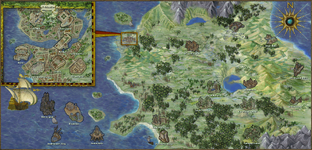
The World Map covers all the areas in the game. You can use it to navigate across long distances.


Baldur's Gate: Enhanced Edition[]

Farmlands (AR0400)Wyrm's Crossing (AR0900)Ulgoth's Beard (AR1000)Ice Island (AR1008)Fishing Village (AR1400)Northwest Baldur's Gate (AR0100)North Baldur's Gate (AR0200)Northeast Baldur's Gate (AR0300)West Baldur's Gate (AR0600)Central Baldur's Gate (AR0700)East Baldur's Gate (AR0800)Southwest Baldur's Gate (AR1100)South Baldur's Gate (AR1200)Southeast Baldur's Gate (AR1300)Cloakwood Druids (AR1600)Cloakwood Wyverns (AR1700)Cloakwood Mines (AR1800)Bandit Camp (AR1900)Cloakwood Nest (AR2100)Cloakwood Lodge (AR2200)Friendly Arm Inn (AR2300)Peldvale (AR2400)Candlekeep (AR2600)Lion's Way (AR2700)Coast Way (AR2800)Larswood (AR2900)Red Wizard Forest (AR3000)Shipwreck's Coast (AR3100)High Hedge (AR3200)Beregost (AR3300)Temple (AR3400)Mutamin's Garden (AR3500)Lighthouse (AR3600)Red Canyons (AR3700)South Beregost Road (AR3800)Ulcaster (AR3900)Gullykin (AR4000)Archaeological Site (AR4100)Fisherman's Lake (AR4200)North Nashkel Road (AR4300)Lonely Peaks (AR4400)Firewine Bridge (AR4500)Durlag's Tower (AR0500)Bear River (AR4600)Xvart Village (AR4700)Nashkel (AR4800)Carnival (AR4900)Valley of the Tombs (AR5000)Gnoll Stronghold (AR5100)Dryad Falls (AR5200)Fire Leaf Forest (AR5300)Nashkel Mines (AR5400)Gibberling Mountains (AR5500)Isle of Balduran (AR1500/AR2000)Adoy's Enclave (OH2000)Cloud Peaks (OH3000)BGEE World Map
About this image

​​​

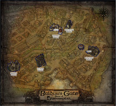
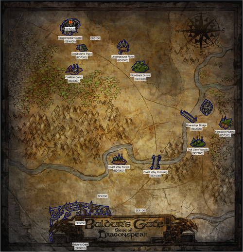
Baldur's Gate: Siege of Dragonspear[]

In Siege of Dragonspear, you only have access to certain maps related to the chapter you are currently in.

Flaming Fist (BD0030)Iron Throne (BD0050)Elfsong Tavern (BD0020)Ducal Palace (BD0010)Three Old Kegs (BD0040)BG:SOD World Map
About this image

Boareskyr Bridge (BD2000)Forest of Wyrms (BD7200)Troll Claw Woods (BD7100)Coast Way Crossing (BD1000)Coast Way Forest (BD7000)Coalition Camp (BD3000)Bloodbark Grove (BD4700)Underground River Entrance (BD5000)Dead Man's Pass (BD7300)Dragonspear Castle (BD4000)Underground River (BD5100)BG:SOD World Map
About this image

​​


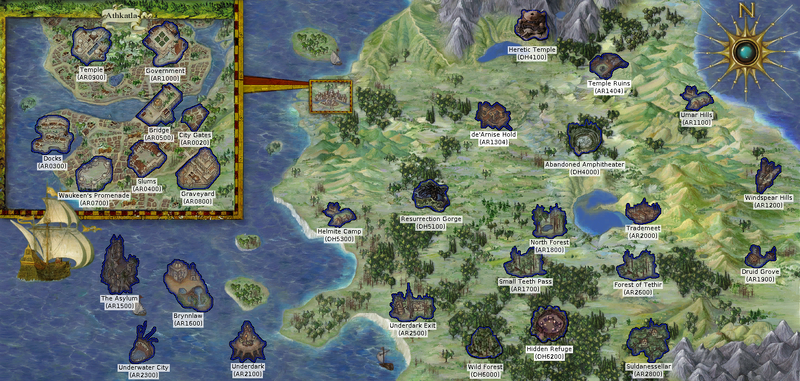
Baldur's Gate II: Enhanced Edition[]

Temple (AR0900)Government (AR1000)Docks (AR0300)Waukeen's Promenade (AR0700)Slums (AR0400)Graveyard (AR0800)City Gates (AR0020)Bridge (AR0500)Heretic Temple (OH4100)The Asylum (AR1500)Underwater City (AR2300)Brynnlaw (AR1600)Underdark (AR2100)Helmite Camp (OH5300)Underdark Exit (AR2500)Resurrection Gorge (OH5100)De'Arnise Hold (AR1304)Wild Forest (OH6000)Hidden Refuge (OH6200)Suldanessellar (AR2800)Temple Ruins (AR1404)Umar Hills (AR1100)Druid Grove (AR1900)Windspear Hills (AR1200)Abandoned Amphitheater (OH4000)Trademeet (AR2000)Forest of Tethir (AR2600)North Forest (AR1800)Small Teeth Pass (AR1700)BGEE World Map
About this image

​​​

The Oasis (AR6300)Watcher's Keep (AR3000)Saradush (AR5000)Siege Camp (AR5203)North Forest (AR6400)Marching Mountains (AR5200)Abazigal's Lair (AR6000)Amkethran (AR5500)Sendai's Enclave (AR6100)Clearing (OH6400)Deepstone Clanhold (OH4200Forest of Mir – The Temple (AR5202)BGEE World Map
About this image

​​​

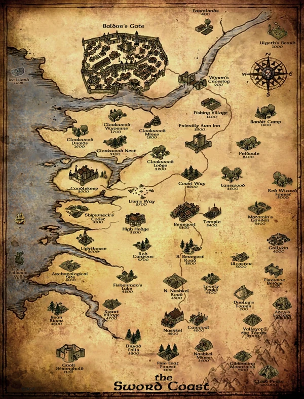
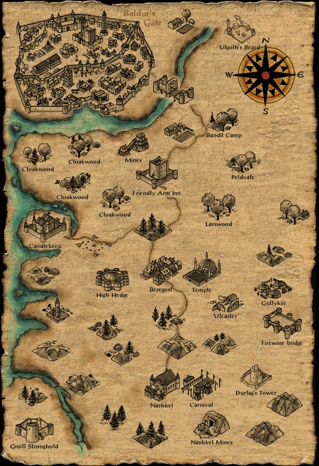
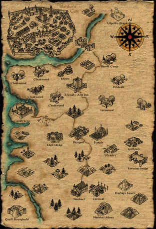
Baldur's Gate & Tales of the Sword Coast[]

Swordcoast

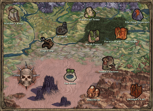
Fully explored original Baldur's Gate world map

The developers gave all of these locations colorful names, but not all are visible in-game. With a few exceptions, such as the Cloakwood forests, the names below are either the displayed names, or an unequivocal description of their geographical location which aids navigation; the more evocative names are shown in their respective articles.

Canon is real life politics in the service of imaginary things that can be fun, and often makes them not; the Baldur's Gate game is surely not seen as canon by some Forgotten Realms players. It is a matter of dispute whether certain areas in the game belong to Western Heartlands or Amn. Some players are ambivalent and subscribe to more expansive definitions of the Western Heartlands with the border line at Beregost, which roughly divides the Sword Coast up into Western Heartlands and Amn. One can also see the Coast as merging from Amn into Heartlands, or that the Heartlands stop at Baldur's Gate, etc. Finally, Amn and the Heartlands can be seen as being divided, with the Sword Coast in between as its own entity.

Categories on this wiki are currently arranged according to the latter viewpoint. There is no strict rule here, only an aesthetic rationale: it is convenient and practical for all of the areas in Baldur's Gate game to be considered part of the Sword Coast; for the Sword Coast to have its own town, Beregost; for the areas around Baldur's Gate City to be in Western Heartlands, and for Amn's borders to be on the same latitude as Nashkel.

Disc 1, the north part of Disc 2, Disc 4 and Baldur's Gate itself are both Sword Coast and Western Heartlands, Disc 3 is Amn. The rest (including Tales of the Sword Coast) are Sword Coast areas.

Disc 1

Disc 2

Disc 3

Disc 4

Disc 5

Candlekeep Friendly Arm Inn Nashkel Fishing Village Baldur's Gate
Lion's Way Cloakwood Lodge Carnival Larswood Central Baldur's Gate
Coast Way Cloakwood Nest Nashkel Mines Peldvale South Baldur's Gate
Cloakwood Druids Fire Leaf Forest Bandit Camp East Baldur's Gate
Cloakwood Wyverns Dryad Falls Spider Wood North Baldur's Gate
Cloakwood Mines Xvart Village Mutamin's Garden Northeast Baldur's Gate
High Hedge Bear River Farmlands Northwest Baldur's Gate
Red Canyons Gnoll Stronghold Ulgoth's Beard

Tales of the Sword Coast IconBaldur's Gate: Tales of the Sword Coast (1999)
This icon indicates content from the original Baldur's Gate: Tales of the Sword Coast campaign.

Southeast Baldur's Gate
Lighthouse Durlag's Tower

Tales of the Sword Coast IconBaldur's Gate: Tales of the Sword Coast (1999)
This icon indicates content from the original Baldur's Gate: Tales of the Sword Coast campaign.

Isle of Balduran South

Tales of the Sword Coast IconBaldur's Gate: Tales of the Sword Coast (1999)
This icon indicates content from the original Baldur's Gate: Tales of the Sword Coast campaign.

Southwest Baldur's Gate
Archaeological Site Valley of the Tombs Isle of Balduran North

Tales of the Sword Coast IconBaldur's Gate: Tales of the Sword Coast (1999)
This icon indicates content from the original Baldur's Gate: Tales of the Sword Coast campaign.

West Baldur's Gate
Shipwreck's Coast Gibberling Mountains Ice Island

Tales of the Sword Coast IconBaldur's Gate: Tales of the Sword Coast (1999)
This icon indicates content from the original Baldur's Gate: Tales of the Sword Coast campaign.

Undercity
Beregost Temple of Bhaal
Temple
South Beregost Road
North Nashkel Road
Fisherman's Lake
Gullykin
Ulcaster
Firewine Bridge
Lonely Peaks

Geographical table map[]

There are 54 mapped areas that can be traveled to above ground, these are all eventually unlocked on the World Map. There are also interiors of dungeons and buildings. Each one has an area code.

The following tables map the main area. They are positioned geographically. Two areas that came with the expansion Tales of the Sword Coast, namely Ulgoth's Beard and Durlag's Tower, though integrated in the map, don't fit into this array due to being added after the technical completion of the main game.

AR0100BG1 AR0200BG1 AR0300BG1 AR0400BG1  
AR0600BG1 AR0700BG1 AR0800BG1 Wyrms crossing  
AR1100BG1 AR1200BG1 AR1300BG1 Area n of bandit camp  
Cloakwood nw Cloakwood ne Mines Bandit camp  
Cloakwood sw Cloakwood se AR2300 BG1 Peldvale  
Candlekeep AR2700 Coast way map Larswood AR3000BG1
Area w of high hedge High hedge AR3300 Temple Area n of gullykin
Lighthouse Area s of high hedge Area S Beregost AR3900 AR4000
Area s of lighthouse Lake Area n of nashkel AR4400 Firewine bridge
Area n of gnoll stronghold Area w of nashkel AR4800 Carnival Area e of carnival
Gnoll stronghold Area e of gnoll stronghold Area s of nashkel Nashkel mines Area e of nashkel mines

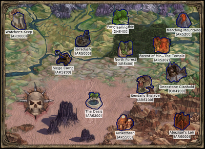
Baldur's Gate II: Shadows of Amn & Throne of Bhaal[]

BG2soamap

Fully explored Baldur's Gate II: Shadows of Amn world map

BG2tobmap

Fully explored Baldur's Gate II: Throne of Bhaal world map


Gallery[]

See also[]

External links[]

References[]

Advertisement